Agios Georgios
Agios Georgios (island) is the big, empty rock sitting right at the mouth of the Saronic Gulf that you’ve probably seen from the ferry to Hydra without knowing its name. Also called San Tzortzis on old charts, it’s 4.3 sq km of low scrub and wind — the largest uninhabited island in the Saronic, officially with zero people, administratively clinging to Hydra even though Lavreotiki tried to claim it.
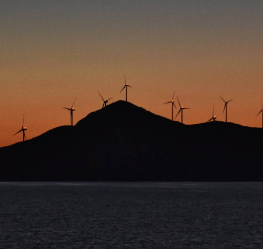
In antiquity it was Belbina, the little polis Herodotus mentions in a spat between Themistocles and Timodemos, and some scholars tried to turn it into Psyttaleia from the Battle of Salamis. Today it’s known for something much louder — since 2014 the whole ridge is covered in a 73 MW wind farm by Terna Energy that feeds about 250 GWh a year into Athens. No tavernas, no port, no beach bar — just turbines, goats, ancient wall traces, and that strange feeling of a completely empty island watching all the traffic go in and out of the Saronic.
Who it suits and why
This one’s for people who want to say they’ve actually set foot on a proper desert island near Athens. This Agios Georgios is the one right in the entrance to the Saronic Gulf. Greek name Άγιος Γεώργιος, also called San Tzortzis or Belbina on old charts. It’s uninhabited, 4.3 km2, and it’s the largest uninhabited island in the Saronic Islands. No houses, no port village, just scrub, rocks and goats. If you like sailing, wild swimming, or you’re doing a Saronic charter, you’ll know it. You don’t get a ferry here. You come by private boat or RIB from Lavrio or Sounion or Hydra, anchor off the east or west coves depending on wind, and jump in. Water is ridiculously clear because there’s literally nothing around it. There’s no organised beach. It’s all natural pebble coves and rocky shelves. You bring everything with you and take everything back. People come for the silence, snorkelling, fishing, and for that sunset lighthouse view. On the south end there’s the Agios Georgios lighthouse. Station from 1901, focal plane at 145m, two white flashes every 15 seconds. It’s still active and you can see it from miles away. And inland now you’ve got the big wind farm, nine turbines that power a lot of Attica. It’s a bit surreal, this empty 4.3 km2 rock making electricity for Athens, but that’s why you’ll see it marked on sailing maps. It’s perfect if you’re sailing between Hydra, Aegina and Sounion and want a truly off-grid swim stop with zero light, zero music, just sea. It’s not for you if you want a base with rooms and tavernas. There are none. Think day trip only, and plan to be self-sufficient.
What to keep in mind
Getting here is all about boats and weather. It sits at 37°28′26″N 23°55′34″E, about 20km south southwest of Cape Sounion, about 12 miles from Sounio and 20 miles from Hydra. No scheduled ferries. From Lavrio it’s about 30 to 45 minutes by speedboat, from Hydra a couple of hours sailing depending on wind. You usually need to charter, around 400 to 700 euro for a half day RIB in high season, split between you. Most people fly UK to Athens, 3.5 to 4 hours, then taxi to Lavrio. Lavrio is the main launch point for this part of the Saronic. Best time is May to October, 24 to 29 degrees, sea 22 to 26. Mornings are calmest. Afternoons in July and August the meltemi builds in the Saronic entrance, 15 to 25 knots, so anchoring gets uncomfortable. Go early, swim, and head back before it picks up. There’s no water, no shops, no bins, no accommodation. Wear proper shoes, the island is rocky with spiky scrub. Bring hat, reef shoes, lots of water, snorkel, dry bag, and take all rubbish back to Lavrio. You can’t stay overnight on the island without permission because of the wind farm infrastructure, and there’s no shelter. Base yourself in Lavrio, Sounion, Aegina or Hydra and do it as a day trip. Check windguru for Saronic Gulf, check with your skipper on swell, and don’t rely on phone signal out there, it’s patchy. And give the turbines and lighthouse compound a wide berth, they’re active and fenced.
Sources
- en.wikipedia.org – Agios Georgios (island) | Greek Άγιος Γεώργιος, uninhabited island in entry of Saronic Gulf, largest uninhabited Saronic island 4.3 km2
- terna-energy.com – Agios Georgios Wind Farm | 4,300 acres, 12 miles from Sounio and 20 from Hydra, benchmark energy project
- ibiblio.org – Lighthouses of Southern Greece – Agios Georgios | Station established 1901, focal plane 145m, two white flashes every 15s, island 20km SSW of Cape Sounion
- mapcarta.com – Agios Georgios Island Saronic | Also known as Ayios Yeoryios Belvina, Belbina, San Tzortzis, island at entrance to Saronic Gulf
Back to all Greek islands
The Greek Island Directory is a project of passion where a love of Crete, Data Integrity and Directories converge to create something truly special for users: Learn More.
Last Updated on August 26, 2026 by admin