Samothrace
Samothrace, or Samothraki, is a rugged mountain island in the far northeast Aegean near the Turkish coast, 178 square kilometres dominated by Mount Saos — Fengari — rising to 1,611 metres, the highest peak in the Aegean islands. Steep, forested and wild, with no real natural harbour, its main settlement is Chora high on the slope above the port of Kamariotissa, and the rest of the island is rivers, waterfalls, plane trees and huge boulders.
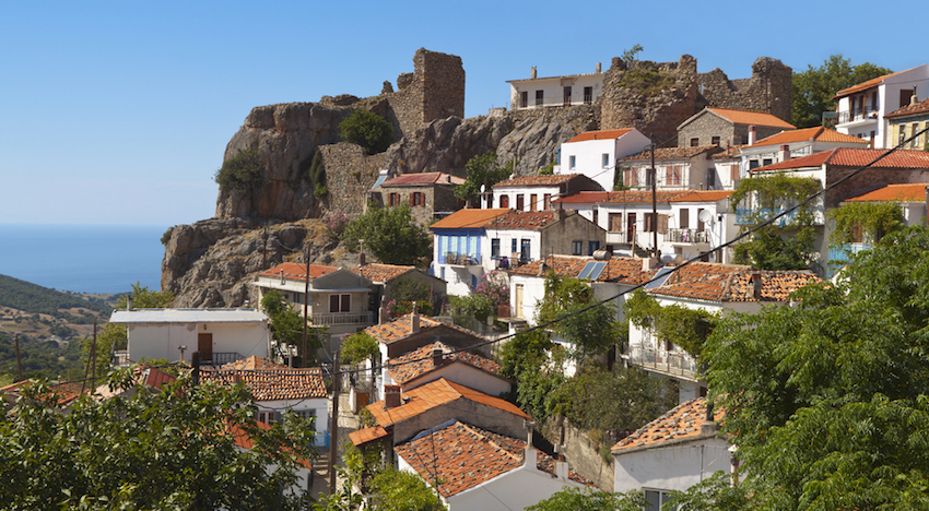
Famous in antiquity for the Sanctuary of the Great Gods, a mystery cult where the Winged Victory of Samothrace — now in the Louvre — stood, Samothrace is today known for its vathres, natural rock pools and waterfalls like Fonia where you hike upriver swimming from pool to pool. Largely untouristy, with cold rivers, goats, and thermal springs at Therma, it feels more like northern Greece than an Aegean island, a place for hiking and camping rather than beach clubs.
The rugged Aegean island with the 1,600-metre Fengari peak
Samothrace, also called Samothraki, is a Greek island in the northern Aegean Sea in the Thracian Sea, off the Macedonian coastline. It is 17 kilometres long, about 178 square kilometres in size, roughly 71 square miles or 184 square kilometres, with a 58 to 59-kilometre coastline, and a population of about 2,600 to 3,083 people. Its main industries are fishing and tourism, with resources of granite and basalt.
It is one of the most rugged Greek islands, an enormous rocky outcrop emerging from the fault line dividing the European from the Turkish and Aegean plates. Mount Saos dominates with its highest peak Fengari — meaning moon — rising to 1,611 to 1,700 metres, the highest mountain in the Aegean region, visible from 100 miles away and mentioned by Homer as a natural beacon for navigation. Snow covers it about nine months of the year. In ancient times Samothrace was an important centre of worship at the Sanctuary of the Great Gods in Paleopolis, and the famous Winged Victory of Samothrace, built around 200 BC, was found here and now stands in the Louvre.
This is for you if you want wild nature, waterfalls, pools, granite gorges and serious hiking up to Fengari, plus ancient mystery cults. It is not for typical beach clubs; Samothrace is remote, wind-swept and elemental.
How to get there & around
The only way to get to Samothraki is by ferry from the mainland. Ferries depart from the port of Alexandroupoli in northern Greece close to the Turkish border — 24 nautical miles away, about two hours — and arrive at Kamariotissa port. The closest airport is Alexandroupoli Airport Dimokritos, with flights from Athens of about one hour, then a bus or taxi to the port and a ferry of 1 hour 45 minutes to 2 hours. Alternative departures exist from Kavala or Thessaloniki with 2 to 3-hour crossings. You can also reach it via Samos through Seferihisar and Keşan, but that takes around 19 hours. On the island itself you need a car, bus or taxi along the coastal road to Therma or Loutra, 15 kilometres from the port, for the hot springs and trails.
Sources
- https://en.wikipedia.org/wiki/Samothrace | island 17 km long 178 km2 rugged Mt Saos highest peak Fengari 1611 m 5285 ft Winged Victory Samothrace statue now displayed Louvre Sanctuary Great Gods
- https://www.factmonster.com/encyclopedia/places/greek-political-geography/samothrace | Samothrace island 1991 pop 3083 c71 sq mi 184 sq km NE Greece Aegean main town northwest shore largely mountainous rising c5575 ft 1700 m Mt Fengari ancient important center worship famous statue winged Nike Victory built c200 BC adorn ship
- https://greece.terrabook.com/samothrace/transportation/ | Samothrace 24 nautical miles about two hours ferry away Alexandroupolis surrounded islands Lemnos Imbros Thasos area 178 square kilometers population 2840 census 2011 mountainous Saos largest mountain highest peak Fegari 1611 meters
- https://scholarblogs.emory.edu/samothraciannetworks/the-island/ | An Island Thracian Sea Geography Meteorology enormous rocky outcrop emerging fault line divides European Turkish Aegean plates reach 1644 m tallest peak region natural beacon navigation visible 100 miles away Homer
- https://allovergreece.com/Cyclades/Best/Samothrace | only way get Samothraki ferry port Alexandropoli mainland northern Greece close Turkish borders ferry ride about 2 hours takes port Kamariotissa closest airport Alexandoupoli from where take ferry
- https://www.visitgreece.gr/ | Athens International Eleftherios Venizelos to Alexandroupolis Dimokritos Flight duration 1 hour then ferry Samothrace Travel duration 1 hour 45 minutes
Back to all Greek islands
The Greek Island Directory is a project of passion where a love of Crete, Data Integrity and Directories converge to create something truly special for users: Learn More.
Last Updated on September 2, 2026 by admin