Santorini
Santorini, or Thira, is the crescent-shaped caldera island that remains after one of the largest volcanic eruptions in history around 1600 BC, 76 square kilometres of black rock rim rising 300 metres above the sea, with the main towns Fira, Imerovigli and Oia perched on the cliff edge. The other half of the caldera, opposite, is Thirassia and the two Kameni islets in the centre, while the eastern side slopes gently to black sand beaches at Kamari and Perissa.
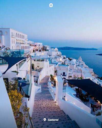
Famous for white houses with blue domes hanging over the caldera, sunsets from Oia, and wines grown in basket-shaped vines in volcanic ash — Assyrtiko above all — Santorini is also the site of Akrotiri, the Minoan city preserved under pumice like a Bronze Age Pompeii. Tourism is intense in summer, with cruise ships, wine tastings and caldera pools, but winter reveals a quieter farming island of 15,000 people living on the rim of an active volcano.
The caldera island — 76 sq km crescent of volcano and villages
Santorini, officially Thira or Thera, is a small circular group of volcanic islands in the Aegean, 75 kilometres southeast of mainland Greece, 200 kilometres southeast of Athens, the southernmost member of the Cyclades between Ios and Anafi. It is the remnant of a volcanic caldera formed by a massive eruption around 1600 BCE that likely led to the fall of the Minoan civilization. It is not one island but an archipelago totalling about 90.69 square kilometres — main island 76 square kilometres, 29 square miles, or 73 to 96 square kilometres by different measures — with a coastline of almost 69 kilometres, length about 16 kilometres north to south, and steep cliffs around the flooded caldera. In 2001 it had 10,700 people, now about 15,500 permanent residents though visitors reach two million annually.
Together with Thirasia, Palea Kameni, Nea Kameni and Aspronisi it forms a semicircular archipelago. The capital is Fira on the caldera edge, while the main port is Athinios which gets extremely busy in summer. Villages like Oia, Imerovigli and Firostefani perch above the caldera. The landscape is carved from lava, with black, red and white beaches and sunsets that define the Mediterranean.
This is for you if you want iconic caldera views, wine terraces and volcanic geology with luxury stays. It is not for quiet isolation or low-cost simplicity; Santorini is busy and built for views.
How to get there & around
Santorini is reached by ferry or flight from Athens year-round. Ferries from Athens port of Piraeus to Athinios operate all year with up to eight daily crossings in summer, run by Blue Star Ferries, Seajets and Fast Ferries. Trip duration ranges from 5 hours to over 11 hours depending on vessel, with fastest high-speed ferries around 5 hours 25 minutes and tickets from €46.50. Seajets services take about 5 hours and cost €89 to €90. Flights from Athens to Santorini JTR run hourly with Ryanair, Volotea and others. On the island you need a car, scooter or local bus — the island is crescent-shaped, villages are linear along the caldera rim, and Athinios port is far below Fira with a steep climb.
Sources
- https://www.greeka.com/cyclades/santorini/geography/ | Santorini consists semicircular archipelago volcanic islands located southern Aegean between Ios Anafi part Cycladic group Greek named Thira Thera land area 96 sq km coastline stretches almost 69 km capital Fira main port Athinios extremely busy summer
- https://www.library.snls.org.sz/santorini-wikipedia | small circular group volcanic islands Aegean 75 km south-east Greece mainland latitude 35.25N longitude 25.20E southernmost member Cyclades area approximately 80 sq km 30 sq mi 2001 estimated population 10700
- https://lifeisabeachparty.com/how-big-is-santorini/ | Size Santorini spans approximately 76 square kilometers 29 square miles Shape crescent-shaped island formed volcanic eruption caldera at center officially called Thira part Cyclades island group crescent shape resulted massive eruption around 1600 BCE created caldera Today spans 76 square kilometers steep cliffs surrounding flooded caldera
- https://funworldfacts.com/santorini-facts/ | small group volcanic islands totaling 90.69 km2 35mi2 one-tenth size Luxembourg remains caldera crater filled seawater erupted many times major eruption 1600 BCE downfall Minoan Civilization Crete
- https://ferryhopper.com/en/ferry-routes/direct/piraeus-santorini | Ferries Athens port Piraeus Santorini operate all year up to 8 daily crossings summer main companies Blue Star Ferries Seajets Fast Ferries arrive port Athinios trip duration ranges 5 hr over 11 hr vessel ticket prices start €46.50
- https://www.directferries.com.au/santorini_athens_ferry.htm | earliest ferry typically departs 03:00 last 19:30 sail around 5 hours 40 minutes fastest approximately 5 hours 25 minutes
Back to all Greek islands
The Greek Island Directory is a project of passion where a love of Crete, Data Integrity and Directories converge to create something truly special for users: Learn More.
Last Updated on September 2, 2026 by admin