
Palea Kameni
Palea Kameni is the older of the two volcanic islets in the centre of Santorini’s caldera, next to its bigger, younger sister Nea Kameni. Just 0.4 square kilometres, formed between 46 and 47 BC according to historical records, it is a low mound of black lava with almost no vegetation, topped by the small church of Agios Nikolaos and surrounded by warm, sulphurous water.
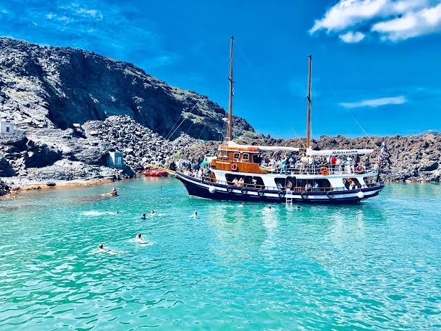
It is most famous for the Hot Springs in the narrow channel between Palea and Nea Kameni, where iron-rich, 30-35°C water bubbles out of the seabed and stains the rocks orange, a regular stop for caldera boat tours where you swim from the boat to the cove. Unlike Nea Kameni you don’t hike a crater here, you just circle it, soak in the warm sea, and see the active volcano from water level with the cliffs of Fira and Imerovigli towering 300 metres above.
The uninhabited islet south of Anafi
Pachia Anafi, Greek Παχειά, is an uninhabited Greek island in the Cyclades directly south of Anafi, the southeasternmost island of the Cyclades east of Thira Santorini. Anafi itself is a small triangular-shaped island covering approximately 39 to 40.370 square kilometres with 293 people in three settlements Anafi, Kleisidi and Agios Nikolaos or Gialos, 155 nautical miles from Piraeus and part of the Thira regional unit.
Pachia itself is a barren volcanic islet with area recorded as 1.55 square kilometres, about 5.18 kilometres long and 3 kilometres wide, rising to 189 metres above sea level at coordinates 36.271722N 25.830563E. It is classified as uninhabited, part of the Anafi municipality and the South Aegean, with no villages, port or infrastructure — just rocky terrain, low scrub and rabbits and seabirds documented by researchers. On sailing charts it appears as Pachia, a small island south of Anafi island, visible in high-definition satellite imagery as a lone elongated rock south of the main island.
This is for you if you want the ultimate Cycladic wilderness seen from a yacht — completely untouched, no houses, no water, no beach bar. It is not for staying overnight, swimming from an organized beach or any services.
How to get there & around
There is no ferry or scheduled boat to Pachia Anafi — you reach it only by private sailing yacht or charter from Anafi. Anafi is reached by ferry from Piraeus or from Santorini Thira, but its harbour at Agios Nikolaos is small and offers little protection so it is seldom visited by yachts. From Anafi town you need to arrange a local boat or rib for the short crossing south to Pachia, anchoring offshore in the blue water and swimming in. On Pachia you move only on foot over rough ground with no marked paths, no shade and no facilities, so bring water, shoes and take everything back.
Sources
- https://mapcarta.com/W280954712 | Pachia uninhabited islet Cyclades south of Anafi Greece Type Island small island south of Anafi
- https://www.findwords.info/term/pachia | Pachia Greek Παχειά uninhabited Greek island Cyclades south Anafi Category Uninhabited islands Greece Landforms Thira regional unit
- https://infodlapolaka.pl/kategorie-en/m/1f0aa5ac-0be6-409e-9d7d-f7b6dfcfd2e0 | Pachia uninhabited area 1,550 km2 length 5,18 km width 3,0 km 189 m above sea level
- https://www.mdpi.com/1420-3049/28/2/654 | 53 Pachia Masseti 36.271722 25.830563
- https://en.wikipedia.org/wiki/Anafi | Anafi Greek island community Cyclades 2021 population 293 land area 40.370 square kilometres lies east of Thira Santorini part of Thira regional unit
- https://www.mdpi.com/2076-3393/11/2/122 | Anafi small triangular-shaped island Cyclades east of Thira 155 nautical miles from Piraeus consists three settlements Anafi Kleisidi Agios Nikolaos Gialos total population 257 area approximately 39 km2 mountainous terrain highest peak Vigla 579 m
Back to all Greek islands
The Greek Island Directory is a project of passion where a love of Crete, Data Integrity and Directories converge to create something truly special for users: Learn More.
Last Updated on August 30, 2026 by admin