Santorini
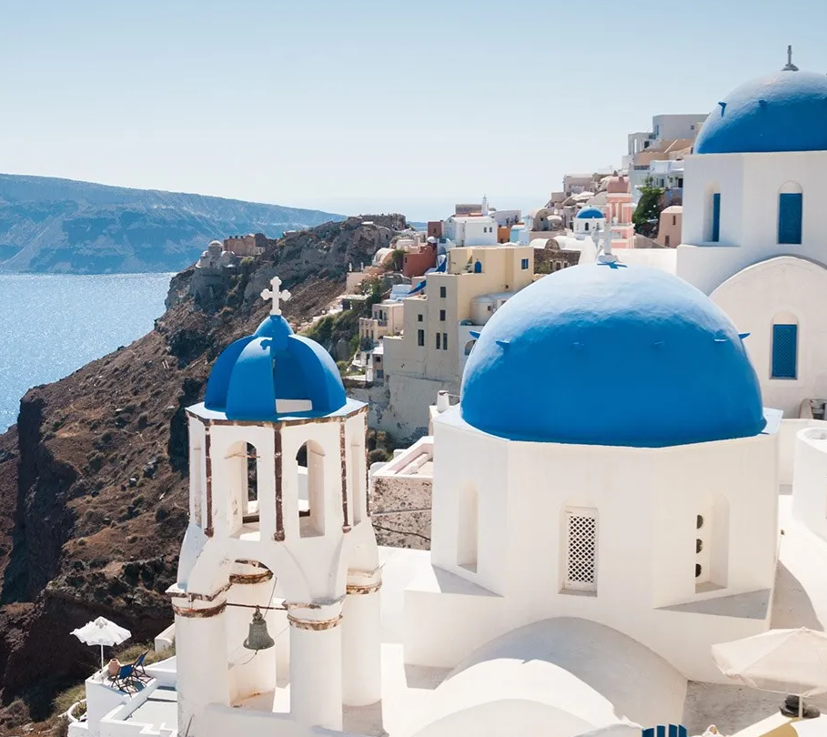
Santorini is a crescent-shaped volcanic island in the southern Aegean Sea formed by the Late Bronze Age Minoan eruption of Thera, whose steep caldera cliffs expose layered pyroclastic deposits, with limited freshwater, predominantly arid conditions, and settlements concentrated along the rim above a submerged caldera that remains volcanically active (notably at Nea Kameni).
Overview
Santorini (ancient Thera) is what’s left of a much larger volcanic island after the Late Bronze Age Minoan eruption of Thera—a massive eruption that blew out the centre of the island, created the caldera, and scattered ash across the eastern Mediterranean, which is why the landscape today feels so dramatic and unlike anywhere else in Greece.
At Akrotiri, a Bronze Age town preserved under volcanic ash, you can still see multi-storey buildings, frescoes, and surprisingly advanced infrastructure, pointing to a well-developed society with strong trade links, while in later periods the island (then Thera) was part of wider Greek expansion, including the founding of Cyrene in North Africa.
The island’s steep cliffs, layered volcanic rock, and active centre around Nea Kameni are all part of the same volcanic system, and they’ve shaped everything from where people live (along the caldera rim in places like Fira and Oia) to how food is grown, with dry conditions and mineral-rich soils behind Santorini’s distinctive wines, while its long run through Byzantine, Venetian, and Ottoman rule still shows up in its architecture and identity today.
Today, Santorini is one of the most globally recognised destinations in Greece, defined by its caldera-edge settlements, volcanic landscape, and preserved archaeological sites such as Akrotiri, with an economy heavily driven by high-volume international tourism, strong seasonal demand, and a concentration of infrastructure around cliffside towns like Fira and Oia, while ongoing volcanic activity centred on Nea Kameni continues to underpin both its geological significance and its modern identity.
| Name | Santorini | Θήρα | Thíra | Thera |
| Demonym | Theran / Santorinian |
| Dialect | Standard Modern Greek (Cycladic variety with minor regional features) |
| Islands Group | Cyclades (Southern Cyclades subgroup) |
| Sea Group | Aegean Sea |
| Vibe | Scenic, dramatic, and highly curated tourism environment combining luxury travel, mass tourism, and iconic landscape appeal |
| Tourism Level | Very high and strongly seasonal, with extreme peak volumes in summer (one of Greece’s most visited islands). |
| Cost | High to very high, especially in caldera locations (Fira, Oia), reflecting global demand. |
| Best Months | May–June and September–October offer warm conditions with reduced crowd density compared to peak summer. |
| Wind | Moderate–strong; influenced by the Meltemi winds in summer (regional Aegean climatic pattern). |
| Beach Type | Predominantly volcanic (black sand, pebbled, and distinctive red/white cliffs), with limited conventional sandy beaches. |
| Food | Known for volcanic-soil agriculture including Assyrtiko wine (PDO Santorini), fava (yellow split pea), and cherry tomatoes. |
| Nightlife | Moderate to active; concentrated in Fira with bars and clubs, quieter and upscale in Oia. |
| Family-Friendly | Suitable in parts, though steep terrain and crowded peak seasons reduce accessibility for young families. |
| Access | International airport and frequent ferries from Piraeus and other Cyclades islands. |
| Transport | Bus network (KTEL), taxis, private transfers; high seasonal demand can strain availability. |
| Car Rental | Widely available and often recommended for accessing beaches and less central villages. |
| Roads | Paved island network; generally adequate but narrow and congested during peak season. |
| Walkability | Partially walkable (high in caldera towns but constrained by steep terrain and distances). |
| Connectivity | Good mobile and internet coverage, especially in main settlements and tourist zones. |
| Infrastructure | Well-developed but under seasonal pressure due to high visitor numbers (water, waste, transport systems). |
| Healthcare | Local hospital and clinics available; serious cases transferred to larger mainland facilities. |
| ATM | Widely available in main towns and tourist areas. |
| Accommodation | Extensive range from luxury cave hotels and villas to mid-range hotels and rentals; strong premium segment. |
| Typical Stay | Commonly 2–4 days, often as part of multi-island itineraries. |
| Population | ~15,550 permanent residents (2021 census, ELSTAT; Municipality of Thira). |
| Expat Community | Moderate and internationally diverse, largely tied to tourism and hospitality sectors. |
| Property and Living | High-value real estate market driven by global demand; strong short-term rental sector and limited affordability for locals. |
| Size | 90.6 km² |
| Geography | Volcanic caldera island with steep cliffs, central lagoon, and active volcanic islets (e.g., Nea Kameni); composed of layered lava and pyroclastic deposits. |
| Elevation | Highest point ~567 m (Mount Profitis Ilias). |
| Culture | Layered prehistoric (notably Akrotiri), ancient Greek (Thera), Byzantine, Venetian (“Santa Irini”), and modern Greek influences shaped by volcanic history and maritime trade. |
Back to Islands
Similar Islands:
Milos • Nisyros • Folegandros • Anafi • Kimolos,
Under:
- Scenic Greek islands, Lively Greek islands, Diverse Greek islands
- Greek islands with Very High Tourism
- Best Greek islands to visit in: May | June | July | August | September | October
- Greek islands Accessible By Boat
- Greek islands Accessible By Ferry
- Greek islands With Domestic Airports
- Greek islands With International Airports
- Greek islands with over 10,000 people
The Greek Island Directory is a project of passion where a love of Crete, Data Integrity and Directories converge to create something truly special for users: Learn More.
Last Updated on July 16, 2026 by admin